Before Bytown – Part 1
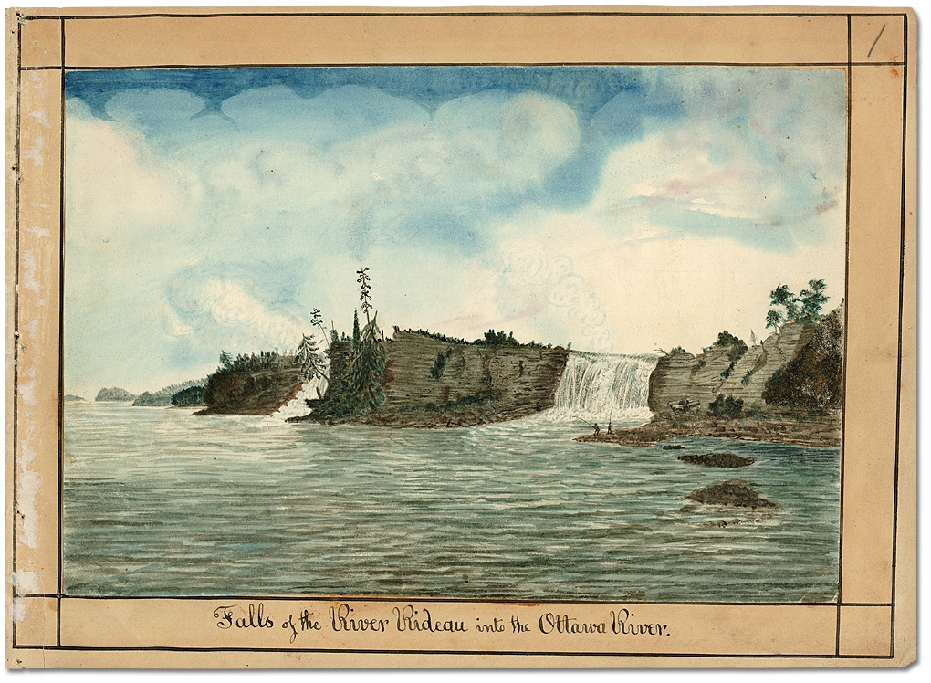
Sketch of the Ottawa River and Rideau Falls in 1826. At this point, they’re still untouched, and looked pretty much the same as they did when Champlain passed them. (Archives of Ontario, I0002118)
Ottawa’s story starts with the river that gave it its name. Of course, it wasn’t always called the Ottawa River. For thousands of years before Europeans arrived, the Algonquin people called the Ottawa River valley home. They knew the river as the Kitchisippi, meaning ‘Great River,’ and used it to trade with other First Nations as far away as the Great Lakes to the west and the Atlantic Ocean to the east.
Samuel de Champlain started making his way down the St. Lawrence in 1603, and by 1611 he had founded the villages that would become Quebec City and Montreal. Champlain maintained a policy of forming friendly, diplomatic relationships with the indigenous peoples he met, and it didn’t take long for him to hear about the great, nature-built highway of the Algonquin.
In 1610, he sent the famous explorer and voyageur, Étienne Brûlé, to explore the Kitchisippi River, or La Grande Rivière des Algonquians, as it was translated by the French. Accompanied by a Huron guide, Brûlé became the first European to travel up the river, and the first European to lay eyes on the cliffs of present-day Ottawa.
That was as far as he would make it on that first trip, unable to pass the great Asticou falls, as they were known to the Algonquin. These massive waterfalls inspired awe in all those who witnessed them at the time, but are hidden by a series of dams, man-made islands, and old mills today. They were called Asticou because that was the Algonquin word for ‘kettle’ and the basin of the falls was extremely turbulent; appearing to bubble like a boiling kettle. The French would simply translate the name to their language, and the falls became known (as they still are) as Chaudière Falls.
Chaudière then is above (Toronto Reference Library, JRR1405) /Chaudière now is below (“Ottawa Chaudiere Falls” by flickr user Shanta – flickr. Licensed under CC BY 2.0 via Commons
In 1613, Champlain took his first trip up the Grande Rivière, and stopped at the present site of Ottawa. He was overwhelmed by the natural beauty of the area, including both the Rideau and Chaudière Falls.
A couple of years later, he travelled further up the River, where he first met the indigenous group that he called the ‘Standing Hairs,’ but who we know today as the Odawa First Nation.
It’s well known today that the naming of the Ottawa River after this indigenous group was a historical mistake. The Odawa traditionally lived on Manitoulin Island and around Lake Huron, not the Ottawa River Valley.

What’s less well known is that the name given to the Odawa themselves may also be a historical mistake. Their name was first recorded in Jesuit records as Outaouak. Later writers, who never had any contact with the group, inexplicably changed the name to Outaouais, and eventually this was anglicized to Ottawa. So, although many people today believe that Ottawa and the River bear an indigenous name, they really go by a decidedly European version of an indigenous name.
Eventually the Champlain expedition reached Lake Huron by way of the Mattawa and French Rivers. The French explorers were starting to understand the incredible accessibility the River gave them to the interior. However, this accessibility didn’t come without serious perils, and not just the dangerous white-water rapids. Between the 1640s and the 1660s, The Iroquois Confederacy waged a war of extermination against the French and their indigenous allies. It was during this period that the Algonquin were largely pushed out of the Ottawa valley and the Odawa took their place in the fur trade. Over time, La Grande Rivière des Algonquians became La Grande Rivière des Outaouais (still known as La Rivière des Outaouais in french today).
Related: The ‘Ugly’ History of LeBreton Flats
For the next hundred years, the River, that had once been the highway of trade and travel for the Algonquin, became the highway of the voyageurs, and the main route of the fur trade. Anyone who wanted to reach the interior used the Ottawa River. Hundreds of explorers, traders, missionaries, surveyors, and soldiers travelled up the River, almost every one of them passing under the cliffs we now know as Parliament Hill.

In 1763, France and England signed the Treaty of Paris, putting an end to the Seven Years War. The English had already expelled the French from Canada three years before, when they stormed Quebec City on the Plains of Abraham. While the Treaty was being negotiated, the French proposed that the British might prefer taking the Caribbean island of Guadeloupe instead of Canada. The British were surprised that the French cared at all about keeping Canada, since France’s leading intellectual of the time, Voltaire, had described the territory as just “a few acres of snow.” The proposal was referred to the British Parliament, where they debated the decision at length. On the one hand, Guadeloupe was an exotic island, with a beautiful climate, and could produce sugarcane, rum, and bananas. On the other hand, Canada was over 5,000 times the size. Parliament voted for size, and Canada became an English territory.
These events completely changed the course of history for Canada, but the Ottawa River and its valley were mostly unaffected. The river remained as a major route for trade and exploration up until the early 1800s, at which point a new, military purpose for the River arose.
You can find part two of “Before Bytown” here.
You can find more writing by Philip Charlebois on his blog, “Ottawa Hockey History.” Also, check it out on Facebook!


